
These are mules. A cross between a horse and a donkey, mules are sure-footed animals that are capable of carrying large loads over long distances. Such loads can include food, Colombian beer, and people (if you are sick or willing to pay). As you can see, Haley is observing the mule (in horror?), not riding it. We did not hire a mule. We are too poor.
We did, however, have an incredible time. Ciudad Perdida (the Lost City), or Teyuna as it is known by the indigenous Colombians, was simply amazing! By the time we finished, we were sore, sunburned, itchy from our various mosquito bites (hopefully none of them containing Zika) and absolutely, thoroughly impressed. I'll do my best to describe what we saw, and I'm going to divide everything into days. Before I begin, however, I need to say this: if you enjoy hiking, traveling, or even just visiting archaeological sites, you need to go. NOW. It was that good.
DAY 1
Day one started with us heading to the Expotur offices to catch our ride up to the trail-head. It was there that we became acquainted with our hiking group, consisting of Ishmael, our guide, Wilson, our cook, three chain-smoking Belgians, a Norwegian, a Mexican and his French wife, a Colombian and his French girlfriend, two very kind Brits, and a happy-go-lucky American gal. It was an interesting crew, and soon we all loaded up in our trusty Land Cruiser (with no air conditioner, mind you) and set off.

We ate lunch in Machete Pelao (the drawn machete), a town at the trail-head, thus named because of the frequent machete fights that used to take place among the town's drunk farmers. We were actually surprised at the amount of foreigners here (especially French people)--it seems like everyone but Americans have figured out that Colombia is worth visiting.


The terrain is largely untouched, though that wasn't always the case. Before the Spanish came, this area was swarming with the Tayrona, an indigenous tribe of Colombia. After abandoning their cities (and being enslaved by the Spanish), the land belonged only to a few farmers. This changed in the 70's when refugees from the interior of Colombia came looking for farmland. They originally harvested cocoa and coffee, but then came marijuana and coca (a plant that acts as a mild stimulant, unless it is processed into cocaine). Both plants are still farmed here to some extent (especially coca, which is still used responsibly by the native tribes), but thankfully the scourge of drugs has gone. A few farmers remain, but the most common source of income is now tourism.
Our first camp consisted of dozens of hammocks, stretched under a crudely constructed shelter. After a pleasant dinner of typical Colombian fare (read: rice and beans) and a cold shower, we went to bed, falling asleep almost immediately.


DAY 2
Probably the hardest day of the four, Friday started out at 5 AM with a quick breakfast, followed by a three hour hike to campsite #2, where we would be having lunch. The already-beautiful scenery only grew more lush and green as the wide trail narrowed and delved deep into the jungle. River crossings were frequent, as were the steep climbs and drops. There wasn't a level part of the trail whatsoever. It was also amazing to see how much elevation we would gain and then lose within such a short amount of time.


We also passed our first Kogi village. The Kogis are the modern day descendants of the Tayronas, and they still live in relative isolation. Few speak Spanish, and they still follow centuries-old customs regarding dress and grooming. Their homes have pointed roofs to represent the surrounding mountains, and they wear white to represent the snow-capped mountains of Santa Marta that are only miles away. Here, two little Kogis approached us to ask for candy. Unfortunately, some of the village children have become quite accustomed to receiving free handouts in the form of "dulces," or "sweets," and they demand it from the foreigners. Luckily, this wasn't the case with all of the children.


Lunch was more of the same, but at least this time it was followed by a really pleasant swim in some blessedly cool water.


After lunch we hiked another 4 hours towards campsite #3, our final destination for the day. We had quite the climb--nearly an hour's worth before finally reaching another fruit stop (fresh pineapple and sour, green lemon/orange hybrids) run by more Kogi villagers. These ones were more open, and their little compound even included a small soccer field carved into the forest mud, complete with two goals and a small, deflated soccer ball. It was amazing to see the pure joy that came from such humble circumstances. There's a lot to be learned from these sweet little ones.


The rest of the day's hike skirted the edge of the river, which soon became swollen from the tropical downpour that enveloped us. Everything that wasn't in bags (which thankfully for us was very little) was instantly soaked, and the trail, which now included hastily made bridges and wooden planks, became slippery and dangerous. After only a slip or two, we made it to our final river crossing, which was done via a tiny metal cage which was pulled across the river with ropes.


We arrived at camp just in time for Haley to collapse, the victim of mild food poisoning, over-exertion, or both. She handled it like a champ--others in our group weren't so lucky. The combination of new food (and massive portions), hard hiking, and potential bacteria led many to lose their lunches. Fortunately, this camp had beds, and a good night's sleep was easily accomplished in spite of the heavy rainfall during the evening.


DAY 3
Day 3 was the day that we'd been hiking for. We woke up at 5 AM again, then headed towards the original stone steps (1,200 of them) that would lead us up to Ciudad Perdida. The steps were laid over the centuries, beginning around 800 AD, 650 years before the founding of Machu Piccu.

We then arrived at the beginning of the complex. Unlike Machu Piccu, which stands starkly by itself in high altitude, Ciudad Perdida seems to be constantly in danger of being digested by vegetation--again. After being abandoned by the Tayrona, it was overwhelmed by the jungle. The wooden huts that used to stand proudly rotted away, leaving only the stone foundations.


The city was rediscovered in 1972 by farmers who stumbled across the stone steps leading up to the city. The farmers pillaged the site, finding gold and gemstones buried in the center of the stone foundations. Soon, grave-robbers flocked to the area, resulting in small-scale battles over control of the site. One grave-robber had enough of the violence and alerted the government to the existence of Ciudad Perdida. The government stationed a few police officers there while a team of archaeologists could be assembled, but by the time they returned, they found that the police officers had killed each other over more pillaging. Fortunately, corruption has decreased tremendously and the park is now well-protected.
The site is massive. There are over 400 stone foundations and terraces, as well as miles and miles of stone walkways and stairs. We stayed up at the site for about 2 hours, and we didn't even see half of the city.


The site culminates in what is known as the "golf course," part of the city that is built on the ridge of a large hill. From here you can see some of the largest stone edifices, which probably held temples and ceremonial huts. The pictures truly don't do justice to the truly massive scale of the area.


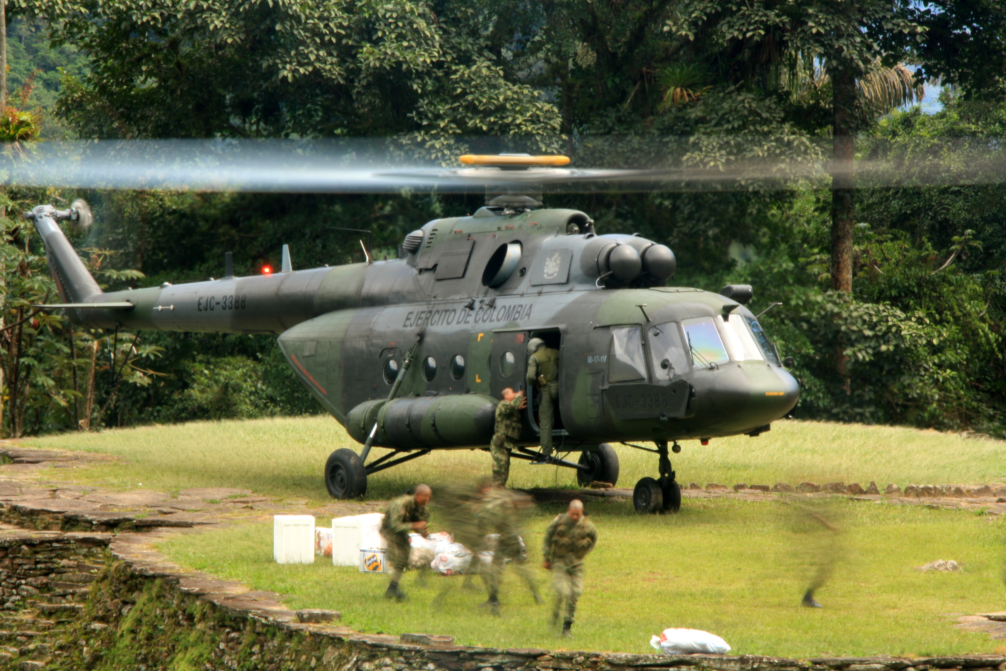
You might think we were higher up than anyone else in the Sierra Nevadas. You'd be wrong. About twenty years ago during the height of Colombia's problems, the ELN (a marxist rebel group) kidnapped 8 tourists at Ciudad Perdida, holding them for a few months before releasing them. Vowing to never let it happen again, Colombia constructed a military base at the top of the city. Over one hundred and fifty soldiers are stationed here, living here for up to six months at a time. They are resupplied by helicopters that actually land on the "golf course" (helicopter picture from wikimedia commons--we didn't get that lucky).


Unfortunately for us, the Tayrona gods are cruel. We were forced to sacrifice (forget/drop) a 360* camera somewhere up in the city. So, if you ever are up there, please take a look for us.
The rest of the day was spent hiking back to camp #2, where we had lunch the day before. It was another 3-4 hours spent walking through another torrential downpour. Fortunately for us, the beds were dry and spirits were high. The day was a success!


DAY 4
We set out again at zero dark thirty--5 AM. This day was long, hot, and brutal. We pushed for 7 solid hours to make it back to the trailhead, where we had lunch and drove back to Santa Marta. It was sad to say goodbye to some good friends, but we were ready for some real showers and dry clothes.


We had an amazing time in Ciudad Perdida, and we highly recommend it. A big thank you goes out to Expotur and our guide Ishmael, as well as our parents for not freaking out too much when we told them we were going to Colombia. We also owe a (tacky) shout out to Oboz for making excellent boots, and Samsung for making a truly waterproof phone with a great camera.
Tomorrow we'll be coming to you from the beach (provided that we have wifi). Be sure to check back soon!
-Konner and Haley
Love this. Welcome back to civilization. Keep the pots coming.
ReplyDeleteLove this. Welcome back to civilization. Keep the pots coming.
ReplyDelete